


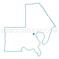
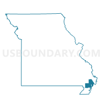
LEWIS 3 Voting District, New Madrid County, Missouri
About
Outline

Summary
| Unique Area Identifier | 609212 |
| Name | LEWIS 3 Voting District |
| County | New Madrid County |
| State | Missouri |
| Area (square miles) | 0.85 |
| Land Area (square miles) | 0.85 |
| Water Area (square miles) | 0.00 |
| % of Land Area | 100.00 |
| % of Water Area | 0.00 |
| Latitude of the Internal Point | 36.56128940 |
| Longtitude of the Internal Point | -89.60035260 |
Maps

Graphs
Select a template below for downloading or customizing gragh for LEWIS 3 Voting District, New Madrid County, Missouri


Neighbors
Neighoring Voting District (by Name) Neighboring Voting District on the Map
- LAFONT 1 Voting District, New Madrid County, MO
- LEWIS 2 Voting District, New Madrid County, MO
- LEWIS 4 Voting District, New Madrid County, MO
- NEW MADRID 2 Voting District, New Madrid County, MO
Top 10 Neighboring County Subdivision (by Population) Neighboring County Subdivision on the Map
- New Madrid township, New Madrid County, MO (3,778)
- Lewis township, New Madrid County, MO (1,802)
- La Font township, New Madrid County, MO (825)